Creating Your Own Caltopo Heatmap
We’ll call this the next edition of OPL’s Caltopo series… jokes aside, there’s an endless number of articles that could be written about ways to use Caltopo. It’s such a powerful tool!
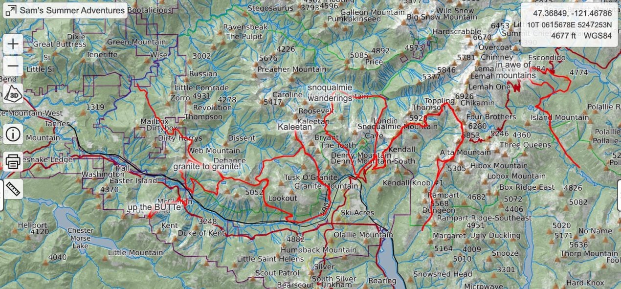
Strava offers a ‘heatmap’ feature that visualizes all of the places you have been by overlaying your historical tracks on one map. It’s fun to look at but it’s also a really helpful tool for creativity. It helps show you where you have been, where you haven’t been, and the in-between blank space of tracks is maybe where you should explore next!
The issue I have with the Strava heatmap feature is it lacks utility beyond eye candy. The Strava basemap just isn’t all that useful for planning purposes, in my opinion. So a few years back I decided to make my own heatmap using Caltopo. I first did it for summer trail runs but quickly started to use it for winter skiing too.
I’ll share a quick method to making a run list/trail list in Caltopo and some tricks that I’ve found to be useful:
Step 1: Create a Structure to Your Map
Before you start drawing lines and marking points, it’s important to have a structure to your map. What is it for? I like to have a map for skiing, by region, for example. Here in Washington I have a few different ‘ski run lists’, as my friend calls them. Let’s start with an example…
I’ll title a heatmap ‘Snoqualmie Pass Skiing’, bound by skiing within the greater Snoqualmie Pass area. I could also make it a map for all of Washington but that might get a little messy and cluttered. Next, I’ll create folders to load different tracks, routes, lines, and points into. I like to make folders by Past and Future: one folder for past trips, at least one folder for Future Ideas.
You can go nuts with folders, but the important thing is to know they are there. Nothing bothers me more than a Caltopo map that is just a mess of ‘Lines and Polygons’.
Step 2: Set Your Default Folder Settings
Now that you’ve made your folders, you can set the items you load into your folders to have different settings on load of the map. For example, if you don’t want everything visible on load, you can turn that off! If you don’t want labels to appear without clicking, you can change that too! The power of Caltopo just keeps on going…
Step 3: Load into Your Folders
Now’s the fun time…load em’ up! I like to export my Strava GPX tracks into Caltopo. I try to keep each track singular (i.e. if I repeat a route I don’t load it in twice) so that the map doesn’t just become a mess of lines. On load, I’ll change the folder of these imported tracks to the ‘Past Trips’ folder so that I can toggle that folder on and off.
Your future folder…well that is where the real fun is! That’s your folder for ideation. What lines do you want to ski? Grab other people’s tracks, draw your own lines…the backcountry is your oyster!
Step 4: Resample GPX Tracks to Downsize
If you load enough GPX tracks in, your Caltopo file will get slow and eventually will crash on load. It’s not designed like the Strava databases that have a robust backend. There’s a way around this, though!
If you resample the GPX tracks you import, you can significantly reduce their file size. It will remove the GPS time/date stamps but those don’t really matter in a Caltopo file. I try to resample to 0.1 or 0.25 mile intervals, but you can change your preferred resolution. The larger the interval you resample at, the smaller the file size.
Go Try It!
Those are the basics…there’s so much more to try and do with Caltopo though. But I love making a dedicated ‘run list’ for skiing and trail running. It helps to have a database of sorts for where you’ve been and where you want to go. Maybe it’s the inner engineer nerd in me, but I find these heatmaps to be super useful, both at home on my desktop and in the field on my phone.
About the Gear Tester
Sam Chaneles
Sam Chaneles is an avid mountaineer and backpacker, climbing peaks in the Cascades, Mexico, Ecuador, and Africa, as well as hiking the John Muir Trail and off-trail routes in Colorado. He has climbed peaks such as Aconcagua, Mt. Rainier, Cotopaxi, Chimborazo, Kilimanjaro, and many more. Sam graduated with a B.S. in Mechanical Engineering from Georgia Tech. During his time there he was a Trip and Expedition Leader for the school’s Outdoor Recreation program (ORGT). He has led expeditions to New Zealand, Alaska, Corsica, France, and throughout the United States. Sam is based in Issaquah, WA just outside of the Cascade Mountains. You can follow Sam and his adventures on Instagram at @samchaneles, or on his website at www.engineeredforadventure.com.

